
Fortæl dine venner om denne vare:
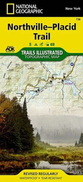
Northville-placid Trail, New York: Trails Illustrated National Parks 2023rd edition
National Geographic Maps
Bestilles fra fjernlager

Northville-placid Trail, New York: Trails Illustrated National Parks 2023rd edition
National Geographic Maps
- Waterproof - Tear-Resistant - Topographic Map
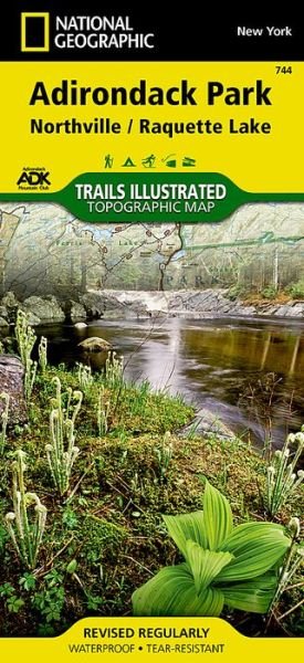
National Geographic's Trails Illustrated map of the Adirondack Park, Northville-Placid Trail combines unmatched detail with helpful information to offer an invaluable tool for making the most of your visit to this 130 plus mile long trail. The Northville-Placid Trail (NPT) is the jewel in the crown of the Adirondack Park trail network. The NPT was constructed in 1923 through remote lake country. The map is expertly researched and created in partnership with the Adirondack Mountain Club (ADK).
This map can guide you off the beaten path and back again through the wildest and most remote sections of the 6.1 million acre Adirondack Park. The trail is commonly traversed from south to north with hikers starting at Northville in the Shaker Mountain Wild Forest. From there hikers travel through the Silver Lake Wilderness then past Piseco Lake and into the West Canada Lake and High Peaks Wilderness areas. The northern terminus of the trail is near the town of Lake Placid, home to the 1980 Winter Olympics. Along the way the numerous features are shown including shelters, designated backcountry campsites, and stream crossings.
Every Trails Illustrated map is printed on Backcountry Tough waterproof, tear-resistant paper. A full UTM grid is printed on the map to aid with GPS navigation.
Other features found on this map include: Piseco Lake, Panther Mountain, Blue Mountain, Vanderwhacker Mountain, Owls Head Mountain, Owls Head Mountain, Adirondack Mountains, Adirondack Mountains, MacIntyre Mountains, Iroquois Peak, Boundary Peak, Algonquin Peak, Tupper Lake, Tupper Lake, Street Mountain, Ampersand Mountain, Upper Saranac Lake. Map Scale = 1:75,000Sheet Size = 25.5 x 37.75Folded Size = 4.25 x 9.25
1 pages
| Medie | Bøger Kort (Land- eller søkort) |
| Udgivet | 2023 |
| Oprindeligt udgivet | 2015 |
| ISBN13 | 9781597756211 |
| Forlag | National Geographic Maps |
| Antal sider | 1 |
| Mål | 108 × 235 × 15 mm · 181 g |
| Sprog | Engelsk |
Mere med National Geographic Maps
![Cover for National Geographic Maps · National Parks & National Forest of the Us [Map Pack Bundle] - National Geographic Destination Map (Kort) [2023rd edition] (2024)](https://imusic.b-cdn.net/images/item/original/452/9781566959452.jpg?national-geographic-maps-2024-national-parks-national-forest-of-the-us-map-pack-bundle-national-geographic-destination-map-kort&class=scaled&v=1713230308)
![Cover for National Geographic Maps · National Geographic Africa Map (Folded with Flags and Facts) - National Geographic Reference Map (Kort) [2022nd edition] (2024)](https://imusic.b-cdn.net/images/item/original/292/9781566959292.jpg?national-geographic-maps-2024-national-geographic-africa-map-folded-with-flags-and-facts-national-geographic-reference-map-kort&class=scaled&v=1713230295)
![Cover for National Geographic Maps · National Geographic North America Map (Folded with Flags and Facts) - National Geographic Reference Map (Kort) [2022nd edition] (2024)](https://imusic.b-cdn.net/images/item/original/339/9781566959339.jpg?national-geographic-maps-2024-national-geographic-north-america-map-folded-with-flags-and-facts-national-geographic-reference-map-kort&class=scaled&v=1713230295)
![Cover for National Geographic Maps · National Geographic South America and Antarctica Map (Folded with Flags and Facts) - National Geographic Reference Map (Kort) [2022nd edition] (2024)](https://imusic.b-cdn.net/images/item/original/346/9781566959346.jpg?national-geographic-maps-2024-national-geographic-south-america-and-antarctica-map-folded-with-flags-and-facts-national-geographic-reference-map-kort&class=scaled&v=1713230295)

![Cover for National Geographic Maps · Road Atlas: Scenic Drives Edition (united States, Canada, Mexico) (Kort) [2023rd edition] (2023)](https://imusic.b-cdn.net/images/item/original/069/9781566957069.jpg?national-geographic-maps-2023-road-atlas-scenic-drives-edition-united-states-canada-mexico-kort&class=scaled&v=1654624565)
![Cover for National Geographic Maps · Pennsylvania Guide Map (Kort) [2023rd edition] (2023)](https://imusic.b-cdn.net/images/item/original/977/9781566957977.jpg?national-geographic-maps-2023-pennsylvania-guide-map-kort&class=scaled&v=1714334936)

![Cover for National Geographic Maps · Road Atlas - Adventure Edition (Kort) [2024th Adventure edition] (2023)](https://imusic.b-cdn.net/images/item/original/890/9780792289890.jpg?national-geographic-maps-2023-road-atlas-adventure-edition-kort&class=scaled&v=1433670741)
![Cover for National Geographic Maps · Acadia National Park Day Hikes Map - National Geographic Topographic Map Guide (Kort) [2023rd edition] (2023)](https://imusic.b-cdn.net/images/item/original/100/9781566959100.jpg?national-geographic-maps-2023-acadia-national-park-day-hikes-map-national-geographic-topographic-map-guide-kort&class=scaled&v=1697947311)
![Cover for National Geographic Maps · World For Kids, The, Poster Sized, Laminated: Wall Maps World (Kort) [2019th edition] (2023)](https://imusic.b-cdn.net/images/item/original/962/9781597755962.jpg?national-geographic-maps-2023-world-for-kids-the-poster-sized-laminated-wall-maps-world-kort&class=scaled&v=1447624459)
![Cover for National Geographic Maps · Grand Canyon National Park Day Hikes Map - National Geographic Topographic Map Guide (Kort) [2023rd edition] (2023)](https://imusic.b-cdn.net/images/item/original/070/9781566959070.jpg?national-geographic-maps-2023-grand-canyon-national-park-day-hikes-map-national-geographic-topographic-map-guide-kort&class=scaled&v=1697947311)
![Cover for National Geographic Maps · Death Valley National Park Day Hikes Map - National Geographic Topographic Map Guide (Kort) [2023rd edition] (2023)](https://imusic.b-cdn.net/images/item/original/974/9781566958974.jpg?national-geographic-maps-2023-death-valley-national-park-day-hikes-map-national-geographic-topographic-map-guide-kort&class=scaled&v=1697947311)
![Cover for National Geographic Maps · Prague (Kort) [2023rd edition] (2023)](https://imusic.b-cdn.net/images/item/original/847/9781566957847.jpg?national-geographic-maps-2023-prague-kort&class=scaled&v=1608797569)
![Cover for National Geographic Maps · Utah National Parks [map Pack Bundle] Adventure Map (Kort) [2023rd edition] (2023)](https://imusic.b-cdn.net/images/item/original/979/9781597755979.jpg?national-geographic-maps-2023-utah-national-parks-map-pack-bundle-adventure-map-kort&class=scaled&v=1418025159)


![Cover for National Geographic Maps · United States, Southeastern Plains And Gulf Coast Adventure Map (Kort) [2023rd edition] (2023)](https://imusic.b-cdn.net/images/item/original/199/9781566957199.jpg?national-geographic-maps-2023-united-states-southeastern-plains-and-gulf-coast-adventure-map-kort&class=scaled&v=1635133424)
![Cover for National Geographic Maps · Yellowstone / grand Teton National Parks, Map Pack Bundle: Trails Illustrated National Parks (Kort) [2010th edition] (2023)](https://imusic.b-cdn.net/images/item/original/002/9781597754002.jpg?national-geographic-maps-2023-yellowstone-grand-teton-national-parks-map-pack-bundle-trails-illustrated-national-parks-kort&class=scaled&v=1418025165)
![Cover for National Geographic Maps · Flagstaff / sedona, Coconino & Kaibab National Forests: Trails Illustrated Other Rec. Areas (Kort) [2019th edition] (2023)](https://imusic.b-cdn.net/images/item/original/157/9781566955157.jpg?national-geographic-maps-2023-flagstaff-sedona-coconino-kaibab-national-forests-trails-illustrated-other-rec-areas-kort&class=scaled&v=1399554792)
![Cover for National Geographic Maps · United States, Southeast Adventure Map (Kort) [2023rd edition] (2023)](https://imusic.b-cdn.net/images/item/original/205/9781566957205.jpg?national-geographic-maps-2023-united-states-southeast-adventure-map-kort&class=scaled&v=1608800716)

Andre har også købt
Se alt med National Geographic Maps ( f.eks. Kort , Paperback Bog , Bog og Løsblad )