
Fortæl dine venner om denne vare:
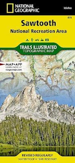
Sawtooth National Recreation Area Map 2023rd edition
National Geographic Maps

Sawtooth National Recreation Area Map 2023rd edition
National Geographic Maps
- Waterproof - Tear-Resistant - Topographic Map
The Sawtooth National Recreation Area, located in the heart of central Idaho, boasts three Wilderness areas: the Sawtooth Wilderness, Cecil D. Andrus-White Clouds Wilderness, and Hemingway-Boulders Wilderness, three mountain ranges: Sawtooth Range, Boulder Mountains and White Cloud Peaks and portions of the Smoky and Pioneer Mountains. The headwaters of four major river systems originate in the NRA, including the Salmon River, which starts its four hundred-mile journey west from the Sawtooth Valley.
Over 300 high-alpine lakes, forty peaks rising over 10,000 feet, and hundreds of miles of trails in the Sawtooth NRA create countless opportunities for recreation including: cross country skiing and mountain biking near Galena Summit, boating on Redfish Lake, and floating the Salmon River.
With hundreds of miles of mapped trails this map can guide you off the beaten path and back again in some of the most breathtaking scenery in the region. Trail mileages, trail use and seasonal closures will assist in choosing the path that is right for you. Recreation features are clearly marked, including campgrounds, trailheads, whitewater access points, interpretive trails, boat launches, Nordic ski areas, and other points of interest. The map base includes contour lines, shaded relief, and elevations for summits, passes and many lakes.
Every Trails Illustrated map is printed on Backcountry Tough waterproof, tear-resistant paper. A full UTM grid is printed on the map to aid with GPS navigation. Map Scale = 1:75,000Sheet Size = 25.5 x 37.75Folded Size = 4.25 x 9.25
2 pages, 1 Illustrations, unspecified
| Medie | Bøger Kort (Land- eller søkort) |
| Udgivet | 2023 |
| Oprindeligt udgivet | 2020 |
| ISBN13 | 9781566958431 |
| Forlag | National Geographic Maps |
| Antal sider | 2 |
| Mål | 108 × 235 × 10 mm · 181 g |
| Sprog | Engelsk |
Mere med National Geographic Maps
![Cover for National Geographic Maps · National Parks & National Forest of the Us [Map Pack Bundle] - National Geographic Destination Map (Kort) [2023rd edition] (2024)](https://imusic.b-cdn.net/images/item/original/452/9781566959452.jpg?national-geographic-maps-2024-national-parks-national-forest-of-the-us-map-pack-bundle-national-geographic-destination-map-kort&class=scaled&v=1713230308)
![Cover for National Geographic Maps · National Geographic Africa Map (Folded with Flags and Facts) - National Geographic Reference Map (Kort) [2022nd edition] (2024)](https://imusic.b-cdn.net/images/item/original/292/9781566959292.jpg?national-geographic-maps-2024-national-geographic-africa-map-folded-with-flags-and-facts-national-geographic-reference-map-kort&class=scaled&v=1713230295)
![Cover for National Geographic Maps · National Geographic North America Map (Folded with Flags and Facts) - National Geographic Reference Map (Kort) [2022nd edition] (2024)](https://imusic.b-cdn.net/images/item/original/339/9781566959339.jpg?national-geographic-maps-2024-national-geographic-north-america-map-folded-with-flags-and-facts-national-geographic-reference-map-kort&class=scaled&v=1713230295)
![Cover for National Geographic Maps · National Geographic South America and Antarctica Map (Folded with Flags and Facts) - National Geographic Reference Map (Kort) [2022nd edition] (2024)](https://imusic.b-cdn.net/images/item/original/346/9781566959346.jpg?national-geographic-maps-2024-national-geographic-south-america-and-antarctica-map-folded-with-flags-and-facts-national-geographic-reference-map-kort&class=scaled&v=1713230295)

![Cover for National Geographic Maps · Road Atlas: Scenic Drives Edition (united States, Canada, Mexico) (Kort) [2023rd edition] (2023)](https://imusic.b-cdn.net/images/item/original/069/9781566957069.jpg?national-geographic-maps-2023-road-atlas-scenic-drives-edition-united-states-canada-mexico-kort&class=scaled&v=1654624565)

![Cover for National Geographic Maps · Pennsylvania Guide Map (Kort) [2023rd edition] (2023)](https://imusic.b-cdn.net/images/item/original/977/9781566957977.jpg?national-geographic-maps-2023-pennsylvania-guide-map-kort&class=scaled&v=1714334936)

![Cover for National Geographic Maps · Road Atlas - Adventure Edition (Kort) [2024th Adventure edition] (2023)](https://imusic.b-cdn.net/images/item/original/890/9780792289890.jpg?national-geographic-maps-2023-road-atlas-adventure-edition-kort&class=scaled&v=1433670741)
![Cover for National Geographic Maps · Acadia National Park Day Hikes Map - National Geographic Topographic Map Guide (Kort) [2023rd edition] (2023)](https://imusic.b-cdn.net/images/item/original/100/9781566959100.jpg?national-geographic-maps-2023-acadia-national-park-day-hikes-map-national-geographic-topographic-map-guide-kort&class=scaled&v=1697947311)
![Cover for National Geographic Maps · World For Kids, The, Poster Sized, Laminated: Wall Maps World (Kort) [2019th edition] (2023)](https://imusic.b-cdn.net/images/item/original/962/9781597755962.jpg?national-geographic-maps-2023-world-for-kids-the-poster-sized-laminated-wall-maps-world-kort&class=scaled&v=1447624459)
![Cover for National Geographic Maps · Grand Canyon National Park Day Hikes Map - National Geographic Topographic Map Guide (Kort) [2023rd edition] (2023)](https://imusic.b-cdn.net/images/item/original/070/9781566959070.jpg?national-geographic-maps-2023-grand-canyon-national-park-day-hikes-map-national-geographic-topographic-map-guide-kort&class=scaled&v=1697947311)
![Cover for National Geographic Maps · Death Valley National Park Day Hikes Map - National Geographic Topographic Map Guide (Kort) [2023rd edition] (2023)](https://imusic.b-cdn.net/images/item/original/974/9781566958974.jpg?national-geographic-maps-2023-death-valley-national-park-day-hikes-map-national-geographic-topographic-map-guide-kort&class=scaled&v=1697947311)
![Cover for National Geographic Maps · Prague (Kort) [2023rd edition] (2023)](https://imusic.b-cdn.net/images/item/original/847/9781566957847.jpg?national-geographic-maps-2023-prague-kort&class=scaled&v=1608797569)
![Cover for National Geographic Maps · Sequoia / kings Canyon National Park: Trails Illustrated National Parks (Kort) [2023rd edition] (2023)](https://imusic.b-cdn.net/images/item/original/989/9781566952989.jpg?national-geographic-maps-2023-sequoia-kings-canyon-national-park-trails-illustrated-national-parks-kort&class=scaled&v=1400072548)
![Cover for National Geographic Maps · Northville-placid Trail, New York: Trails Illustrated National Parks (Kort) [2023rd edition] (2023)](https://imusic.b-cdn.net/images/item/original/211/9781597756211.jpg?national-geographic-maps-2023-northville-placid-trail-new-york-trails-illustrated-national-parks-kort&class=scaled&v=1668809812)
![Cover for National Geographic Maps · Utah National Parks [map Pack Bundle] Adventure Map (Kort) [2023rd edition] (2023)](https://imusic.b-cdn.net/images/item/original/979/9781597755979.jpg?national-geographic-maps-2023-utah-national-parks-map-pack-bundle-adventure-map-kort&class=scaled&v=1418025159)


![Cover for National Geographic Maps · United States, Southeastern Plains And Gulf Coast Adventure Map (Kort) [2023rd edition] (2023)](https://imusic.b-cdn.net/images/item/original/199/9781566957199.jpg?national-geographic-maps-2023-united-states-southeastern-plains-and-gulf-coast-adventure-map-kort&class=scaled&v=1635133424)
![Cover for National Geographic Maps · Yellowstone / grand Teton National Parks, Map Pack Bundle: Trails Illustrated National Parks (Kort) [2010th edition] (2023)](https://imusic.b-cdn.net/images/item/original/002/9781597754002.jpg?national-geographic-maps-2023-yellowstone-grand-teton-national-parks-map-pack-bundle-trails-illustrated-national-parks-kort&class=scaled&v=1418025165)
![Cover for National Geographic Maps · Flagstaff / sedona, Coconino & Kaibab National Forests: Trails Illustrated Other Rec. Areas (Kort) [2019th edition] (2023)](https://imusic.b-cdn.net/images/item/original/157/9781566955157.jpg?national-geographic-maps-2023-flagstaff-sedona-coconino-kaibab-national-forests-trails-illustrated-other-rec-areas-kort&class=scaled&v=1399554792)
![Cover for National Geographic Maps · United States, Southeast Adventure Map (Kort) [2023rd edition] (2023)](https://imusic.b-cdn.net/images/item/original/205/9781566957205.jpg?national-geographic-maps-2023-united-states-southeast-adventure-map-kort&class=scaled&v=1608800716)
Andre har også købt

Se alt med National Geographic Maps ( f.eks. Kort , Paperback Bog , Bog og Løsblad )